Mapbox, a provider of innovative mapping, navigation and location-based technologies, has announced that the Toyota Motor Corporation will integrate Mapbox software within its in-vehicle navigation systems.
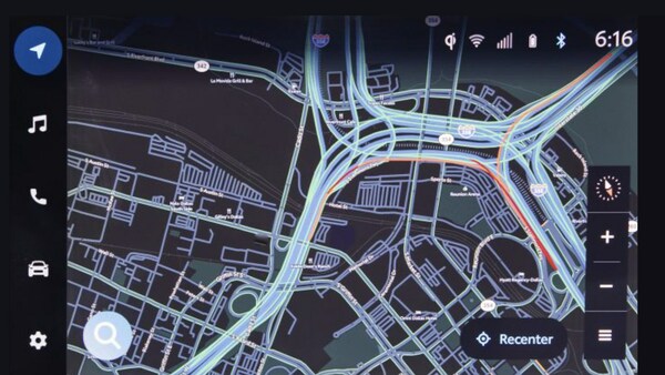
Mapbox’s platform supports the custom development and fast rendering of digital maps for the new Toyota navigation system. According to Mapbox, the high-performance maps provide drivers with relevant information as a simple visual interface, the design of which can be updated quickly and remotely.
Akin to the experience of a smartphone, the map view can smoothly rotate, zoom in and out, and adjust displayed information in response to vehicle location, navigation along a route or user interactions.
In addition to performance enhancements, drivers will notice updates to the visual design of the Toyota in-car maps. Mapbox maps can be entirely customized to any brand or use case, from precise control over colors and fonts to the ability to create and emphasize particular points of interest that are relevant for users.
In-car navigation systems are another feature undergoing improvements as auto makers invest in infotainment systems and navigation enhancements. Modern map design and rendering is now an essential, expected part of the user experience (UX), so auto makers expect map technology that displays buildings precisely and includes rich peripheral information such as stores and points of interest.
Furthermore, UX designers and auto makers expect greater control over the visual design of maps to match the concept of the vehicle and the expansion of navigation features. Using a cloud-based map platform like Mapbox means that design and data updates can be published anytime without needing to wait for drivers to upgrade their software.
New features that Mapbox is launching with automotive partners to enhance navigation systems include the MapGPT AI voice assistant service, which allows for the creation of customized voice assistants capable of engaging in natural conversations about dynamic aspects of the world, utilizing continually updated location data courtesy of the Autopilot Map.
For an aesthetically pleasing navigation experience, Mapbox 3D Live Navigation combines 3D lane models, real-time sensor information, sign data, environmental models, landmark buildings, dynamic lighting conditions and weather data. Similarly, Mapbox Dash integrations for in-vehicle infotainment (IVI) combine maps and navigation with vehicle systems data and entertainment functions, fostering a safe and hands-free driving experience through features like speech recognition and dialogue options.
Additionally, Mapbox for EV offers an end-to-end solution for electric vehicles, accurately predicting range, suggesting optimal charging locations and enabling payments directly from the infotainment screen at the charging location.
With modular software development kits (SDKs), Mapbox can also provide flexible developer resources for tailored implementations, offering specialized tools such as the Navigation SDK for route planning, the Maps SDK for map rendering, the Search SDK for address search and the ADAS SDK for safety-critical attributes like road curvature, slope and speed limits.
For more connectivity news, please click here.


